
US 101 Photo Gallery
| |
US 101 Photo Gallery
Orange County and San Diego County |
Much of US 101 through Orange County has been replaced or modified, but there are still sections that look almost the same as when they were used almost half a century ago.
![]()
This alignment of US 101 was built in 1938 and was superseded by the freeway in 1959. Despite being bypassed, this section is still important, as it has a lot of businesses over it, which is apparent from some the photographs here
.![[Suicide lane in Mission Viejo]](../us_pix/101_pics/us-101_i.jpg) |
![[Close up of suicide lane]](../us_pix/101_pics/us-101_k.jpg) |
| This section is located in Mission Viejo, just west of I-5. The third lane in the middle of the road is called a suicide lane. This road is now known as Camino Capistrano. Notice how this follows the railroad tracks. | |
![[US 101 Oso Creek Bridge]](../us_pix/101_pics/us-101_l.jpg) |
![[US 101 Oso Creek Bridge]](../us_pix/101_pics/us-101_n.jpg) |
![[US 101 Oso Creek Bridge]](../us_pix/101_pics/us-101_m.jpg) |
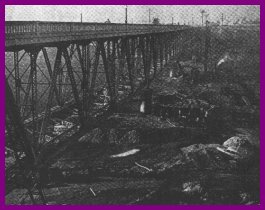
US 101 Crossing Oso CreekThis bridge was built in 1938 to replace the previous one which had been washed out by a flood earlier that year. |
![[1941 and pre-1938 alignments]](../us_pix/101_pics/us-101_o.jpg) |
![[Close-up of pre-1938 alignment]](../us_pix/101_pics/us-101_p.jpg) |
![[1941 alignment]](../us_pix/101_pics/us-101_q.jpg) |
Top left: The upper section of highway was built in 1941 as part of a major realignment of the neighboring Santa Fe railroad. The old road was replaced to accommodate the new alignment of the railroad and was paid for by Santa Fe. The first paved road was 15' concrete and was widened in 1925. These pictures were taken north of the Junipero Serra Road exit of I-5 in San Juan Capistrano. |
![[Older alignment over 1920s pavement]](../us_pix/101_pics/us-101_s.jpg) |
 |
|
Top: The bottom (1925) alignment covers the original paved alignment; this is known as "second story" concrete. Below: Remnants of the original concrete. This was a 15' wide single slab of concrete, unlike the later two alignments which have two parallel slabs. The later alignment of 101 is to the left (west). |
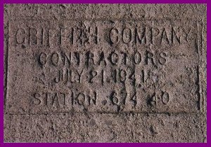
Top: Contractor's Stamp from the top alignment. Reads "Griffith Company Contractors July 21, 1941" Below: Another view of the original alignment. This curve is extremely banked like the Ridge Route north of Los Angeles which was built at the same time. |
![[Original 1920s era pavement]](../us_pix/101_pics/us-101_t.jpg) |
![[Original 1920s era pavement]](../us_pix/101_pics/us-101_u.jpg) |
Unlike in Orange County, most of US 101 is intact in San Diego County and virtually unchanged in many places. US 101 through much of San Diego County has been signed as an historic route.
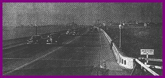
US 101 followed two distinct alignments, with I-5 being a third. The sections US 101 pictured below were originally constructed in 1938 and replaced an alignment built in the 'teens. This alignment was paved with asphalt and was four lanes the whole length. It was modified in 1946 with the addition of the concrete lanes on the outside, presumably to compensate for the majority of the traffic being in the right lane. It saw service until 1968 when it was replaced by I-5. It has since been converted into a bike path and parking for San Onofre State Beach.
![[US 101 bridge over San Mateo Creek]](../us_pix/101_pics/us-101_h.jpg) |
![[San Mateo Creek Bridge]](../us_pix/101_pics/us-101_f.jpg) |
| Above: Southbound lanes of US 101 over San Mateo Creek near the county line. This bridge, constructed in 1946 carried the southbound lanes until the completion of I-5 in 1969 (high level bridge in background). The northbound bridge was removed for the construction of I-5. Note the lane markings are still visible on the picture to the right. | |
![[Typical abandoned stretch of US 101]](../us_pix/101_pics/us-101_c.jpg) |
![[Mileage sign]](../us_pix/101_pics/us-101_a.jpg) |
| Typical abandoned section. Note concrete and asphalt pavement. The pole and cable fence was added in the early 1960s in response to a large number of head-on collisions due to the narrow 6' median. | Mileage sign. Reads San Clemente 12; Anaheim 48; Los Angeles 76. Sadly, this sign, which had been deteriorating for years, was finally lost to the "Ammo" fire of October 2007. This picture was taken almost 20 years earlier in 1988. |
![]()
![[Bridge in Oceanside]](../us_pix/101_pics/us-101_w.jpg) |
![[Bridge in Oceanside]](../us_pix/101_pics/us-101_v.jpg) |
| This bridge crosses the San Luis Rey River just to the north
of Oceanside. It originally dates from the 1930s and served southbound traffic for the
1954 Oceanside Carlsbad Freeway. Above: the bridge in 1997. Below: The bridge in 1951, before the construction of the freeway. |
|
 |
 |
Top of Page
![]()
 |
Related US 101 Photo Album pages
|
![[Historic Highways Logo]](../logos/small_hcuh_banner.gif)
Go to the Historic California US Highways Main Page
![]()