 |
US 66, 91, 395 Inland Empire and Cajon Pass |
 |
| |
US 66, 91, 395 Inland Empire and Cajon Pass |
|
 Click on image for larger view (~60 kb) |
The Cajon Pass has always been an important gateway to
southern California. It is one of the few low places along the coastal ranges where it is
feasible for railroads and highways to cross. Unfortunately, Cajon Pass was created by the
San Andreas Fault which separates the San Gabriel Mountains from the San Bernardino
Mountains. Despite this recipe for disaster, many highways have been built. The first was
a precipitous toll road followed by the first paved highway, built by the state in 1916.
This alignment soon became obsolete and was replaced by a more modern alignment in 1931.
This, of course, proved inadequate and was widened in 1953; that alignment, in turn, was
replaced by I-15 in 1969. At left is a cover of the California Division of Highways (now CalTrans) in house publication called California Highways and Public Works. This was published between 1927 and 1967 and is an invaluable resource for researching California's highway history. The issue at left shows US 66/91/395 going over Cajon Pass, soon after its completion in 1953. The roadway at right is the original 1931 alignment and today is all that remains of the old road. |
1931 Alignment
 Click on image for larger view (~35 kb) |
| This map from 1931 shows the vast improvement of the new alignment over the old. Bear in mind that the two were separated by only 15 years! The 1931 alignment was engineered well enough so that when the highway was later improved, the improvement only consisted of adding an additional roadway and was effectively in use for the next 38 years until its replacement by I-15 in 1969. |
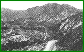 |
This picture shows the old alignment of US 66 (this did not become US 395 until 1936) and the outline of the new alignment is to the left. |
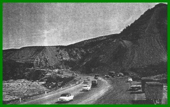
| Upgrade to Expressway Standards The pictures at right show the amount of work that had to be done in order to modernize the road. The picture above shows the raising of the bridges over Cleghorn Creek due to alluvial runoff. Below, traffic goes along the original alignment as new northbound lanes are constructed. This picture was taken in the vicinity of Blue Cut. |
 |
 |
![]()
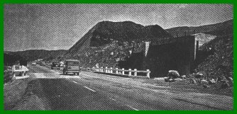
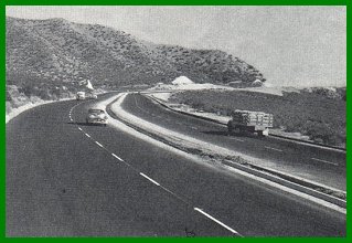
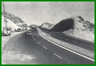
While US 91 and US 395 had been widened to four lanes up to the Gish underpass, the portion to beyond Cajon Summit was not widened until 1955. As the pictures show, this was a very modern highway, complete with the channelized divider and was a huge improvement over the previous alignment. However, this incarnation was to last only 13 years as it was buried under the eight lane alignment of its successor, I-15. Today, most of the grade for the old road is now part of the southbound lanes, although in a few places, the two do diverge.
Photographs below are courtesy of Caltrans
 |
 |
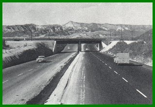
| Above: The Gish Underpass as it appeared
after the widening. The bridge still exists, but the only thing left of the highway is a
dirt grade. Below: Approaching Cajon Summit from the south. At this point, the current southbound lanes of I-15 diverge slightly to the right; the grade for the curve in the middle is still visible. |
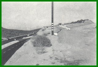
Above: Old and new roads over Cajon
Summit. The new road significantly decreased the height of this summit, making travel
easier. The old alignment is visible to the right and is fenced off near the edge of the
cut. Below: Another view directly to the south of the summit. This is a construction view, showing the last phases of construction along the improved highway. |
 |
 |
 |
US 66 Photo AlbumLos Angeles Area
|
 |
US 91 Photo AlbumNorth - High Desert
|
 |
US 395 Photo AlbumNorth - Mojave Desert
|
![[Historic Highways Logo]](../logos/small_hcuh_banner.gif)
Go to the Historic California US Highways Main Page
![]()
If you have any questions, comments, or if you would like to send me any updates or pictures, please contact me at: casey@gbcnet.com.
http://www.gbcnet.com/ushighways/395pics3.html