US Highway 6
The Midland Trail
Background
![[US ]](../us_pix/Midland_sign.jpg)
Midland Trail Sign
US Highway 6The Midland Trail
|
|
Background |
US 6 was the longest US Highway, once going 3517 miles coast to coast from Long Beach to Provincetown on Cape Cod, Massachusetts. Today it remains the second longest, being only 116 miles shorter than US 20. US 6 seems more of a Frankenstein's monster of highways than a single route since it is a patchwork of what can be many different highways. It heads north/south in some places, east/west in others, and diagonally. For this reason, it is in apparent violation of highway numbering convention as it starts in Cape Cod, north of all but US 2 and US 4 then ends in Long Beach south of US 70. It is generally agreed the US 6 is not a violation since its general route is east/west in accordance with the even number. It also appears that while it was a rule that all highways ending in 0 or 5 needed to conform to a grid, it was permissible to assign diagonal routes to other numbers. US 6 offers the best cross section of the United States possible, going through arid desert, rugged mountains, the Great Plains, and the forested land of the northeast United States. |
|
Midland Trail Sign |
|
![]()
US 6 originally ended in Denver, Colorado in 1926. Around 1938 it was extended west to the Los Angeles area. It started at the Long Beach traffic circle then headed north away from Los Angeles1. It was co-signed with US 395 to Bishop, where it diverged. From there it mostly followed its current course with only few exceptions. Its eastern terminus was, and still remains, Cape Cod, Massachusetts.
US 6 is completely intact outside of California. In some states, such as Colorado and Utah, US 6 has been co-routed with Interstates with no visible sign that it exists, but it remains a through route.
On July 1, 1964, US 6 was almost completely eliminated in California. Only a small portion, from Bishop to the Nevada border, a distance of approximately 40 miles remains. Portions of US 6 remain as signed highways including SR-1, I-110, I-5, SR-14 and US 395. In my opinion, US 6 should have been retained, at least through the I-5/SR-14 junction north of San Fernando.
** Since July 1, 1964, the western terminus of US 6 has been marked by the intersection with US 395 in Bishop.
![]()
Future
![]()
Under Construction
![]()
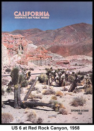
Mike Ballard has created a "Virtual Tour" for US 6 in the Santa Clarita area. It currently extends from the US 6 / US 99 (I-5/SR-14) interchange to Red Rock Canyon. The tour includes many pictures of key points along the route and describes the route and local history in detail.
Dale Sanderson has an excellent page documenting the end of US 6 in Cape Cod.
![]()
![[Historic Highways Logo]](../logos/small_hcuh_banner.gif)
Go to the Historic California US Highways Main Page
![]()
1 Whether this description of the routing is accurate remains unclear. I have seen maps that show US 6 being signed with US 91 and others that show it ending before the Long Beach Traffic Circle. I will update this as soon as I have concrete evidence proving one or the other. Until then I like to think they were co-signed.