Glossary
of Highway Terms
What is "Daylighting?" What's the difference between an
"Interstate" highway and an "interstate" highway? I have included this
glossary to answer such questions by defining and clarifying ambiguous terms. While I am
sure that many people reading this page are familiar with most of the terms here, I want
to make sure some of the technical terms I use in my page are defined and understood.
Alignment
As used on this page, an alignment is the specific location
a route traversed. For example, Highway XX originally follows Main Street
through the town of Podunk. Main Street is the alignment. Taken further, a
freeway bypasses Podunk and becomes the new Highway XX. The freeway bypass is
now the alignment of Highway XX.
Concrete
This is the generic term for paving
on modern highways. The key to this form of paving is that it is composed of tiny stones
bound by an agent - either cement or something petroleum based. There are two major
subtypes: cement-based Portland Cement Concrete (PCC) and
petroleum-based Asphaltic Concrete
(AC).
Portland Cement Concrete
Known since the Romans made widespread use of it, it is the white, durable substance, made from gypsum,
that is commonly known as just "concrete." The name comes, not from the city in
Oregon, but one in England where this form of cement originated. Between the two, the
Portland Cement is the more durable, but it is also far more expensive.
Asphaltic Concrete Otherwise
known simply as "asphalt," this
is the black substance based on either macadam or a petroleum based substance - it is also
known as "tarmac" (tar macadam). While it is not as durable as Portland Cement,
it is much cheaper initially and is more flexible in where it can be used.
Concrete Slabs
Concrete is paved in In this page I use the terms single, double
and sometimes triple slab concrete. What these terms refer to is the number of
parallel slabs on a section of highway that usually correspond with the lanes on a
road. Concrete is divided into square or rectangular segments to accommodate its expansion
and contraction due to changes in weather. This prevents cracking and the ultimate pot
holes. From the driver's point of view a two lane concrete road has one line down the
middle, which delineates the two slabs. Here are the specifics:
- Single Slab: In the 1910s and 1920s, almost every concrete road was paved with
one slab usually 15-16' wide and sometimes up to 20' across. While it was a technical marvel
in the early part of the century when paved roads were novelties, it grew
quickly outdated. Examples of this construction include the Ridge Route and portions of
old US 80.
- Double and Triple Slab: The successors to "single slab." Double
slab was used on two lane, two way roads, such as the 1930s alignment of US 80. Triple
slab was almost exclusively used for roads with "Suicide Lanes," such as the
1933 alignment of US 99 over the Grapevine and a portion of preserved US 101 in Laguna
Niguel.
Of course there are roads with more slabs, but most are associated with the Interstate
Highways or with the advent of freeways and expressways. An example is that an eight lane
concrete freeway is usually made of two parallel roadways made of four
("quadruple") slab concrete, although technically it is only two because of slip
form paving.
| Daylighting
Early state highways in California were built to
conform with the terrain, a construction method that both reduced the
highway grade and cut costs. Unfortunately, the result was dangerous blind
hairpin turns. By the early 1920s, road building technology advanced to
the point where the need for such sub-standard designs was obviated, yet
many older highways still had them. Daylighting was the process of taking
away enough of a hillside to add visibility to sharp turns, making them
safe. A very notable example of daylighting is on the old Ridge Route
north of Los Angeles. |
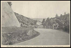
Caption reads: "State Highway, Los
Angeles County, on the Ridge Route, Showing Day-Lighting on Slopes on
Curves." From the California Highway Commission's 1920 Biennial
Report.
Courtesy of Caltrans |
Interstate Highways
This refers to highways
that go through more than one state. This term is most often associated with the Interstate Highway System, but they are not the only interstate
highways. An interstate (note the lower case "i") highway also refers to the US highways and state highways that maintain a route
number through more than one state. The earliest interstate highways include the National Road and Lincoln Highway, both of
which traversed many states. In short, interstate highways are highways that go through
more than one state; the Interstate Highway System is just one set of highways that
matches this definition.
This refers to the interstate system of limited access highways which is denoted by a
red, white, and blue shield. This is also the largest single publics works project in
history. This system was conceived to overcome the shortcomings of the US
Highway System, and was first proposed in 1947 as a 40,000 mile system of highways.
While most of the present highways were designated in 1947, it was not until 1956, with
the passage of the Federal Aid Highway Act of 1956 that they received a funding mechanism.
President Eisenhower was the championed this system; hence their title as the
"Eisenhower Interstate Highway System". It is said that Eisenhower was so
impressed by the German autobahns while he was the Supreme Allied Commander that he wanted
a similar system of highways in the United States which would allow for better military
mobilization and promote better interstate commerce.
As a testament to the national priority that was set for these highways, they
received
an unprecedented funding mechanism. Previously, federal highways had been funded by a
50/50 funding mechanism; the states were required to match federal spending dollar for
dollar. This new mechanism called for the federal government to pay for 90% of the
construction costs, with the states matching only 10%. The Federal Highway Trust Fund was
another first as it was the first time that federal dollars were specifically collected
and earmarked for one project.
The Interstate Highway System was originally to be a 42,000 mile system with the
scheduled completion in 1972. It was not finally deemed complete until 1992, 20 years
later. Even now, new Interstates are planned and it is likely that as long as the system
exists, there will always be some fine tuning. In 1968, the system was modified again,
with the major reallocation of funding for some routes.
In theory, the Interstate Highway System is based on a grid pattern, with a logical
ordering of numbers. In reality, geography, bad planning, and boneheaded politicians (Bud
Schuster) skew this. The following describes the numbering scheme behind this system.
North-South: Odd numbers mark north-south highways, with numbers ranging
from 5 to 99. The lowest numbers are situated on the west and they increase toward the
east; I-5 is furthest west and the numbers increase from there to I-95 on the east coast.
Major interstates, the one that go through more than one region, end in 5; the other
numbers are either regional or intrastate.
East-west Even numbers mark east-west interstates, with numbers ranging
from 4 to 98. The numbers increase going from south to north; I-4 is in Florida, while
I-94 is located near the Canadian border. Major interstates that go through more than
one region or are transcontinental, end in 0; the others are usually regional or
intrastate.
Three Digit Interstates These can best be described as the
"children" of the one and two digit interstates. Their primary purpose is to
extend the reach of interstates in major populated areas and go where the two digit
interstate does not. Their structure is I-Xyy, where X is a number between 1-9 and yy is
the number of the "parent" interstate. When X is an odd number, it signifies
that the route is a spur - it's termini are not necessarily at another Interstate. When
X is an even number, it signifies that the route is a loop - it starts at an Interstate
and ends at an Interstate. All but a few (such as I-205 between Oregon and Washington)
remain in one state entirely.
Exceptions exist for various reasons such as I-99 (politics), I-81
(geography), or I-238 (see my I-238 Page).
Highway Types
In California, US highways took on
all different forms of highway types from two lane conventional roads to modern freeways.
The following is a list of terms and their definitions in the context of California. There
are also some non-California terms that are applied to US highways in other states.
- Conventional Highway: As the name implies, this is the standard arterial road type
in California. They can vary in width from two lanes to eight, but generally top out at
four. They look and feel like a normal street, complete with stop signs, signals, and full
access from businesses and residences.
- Expressway: On the East Coast, an expressway is the catchall term for a
grade separated limited access highway. In California an expressway is simply a limited
access highway; essentially a freeway with at grade intersections, but divided and built
to freeway standards. Technically, in California all expressways are freeways, but in
general practice expressways are a different entity. Originally many current freeways were
constructed as expressways during the late 1940s and early 1950s and had grade separated
interchanges added later. Examples of expressways include SR-111/SR-86 between Indio and
El Centro, SR-152 between SR-99 and the Pacheco Pass, and SR-76 to the north and east of
Oceanside.
- Freeway: Generally a freeway is a grade separated divided highway
designed for high speeds. Contrary to popular belief, a freeway is not a highway
"free" from tolls. The "free" in freeway instead refers to a
legislative definition passed by the California Legislature in 1939, which provided for a
highway that would be free of encroaching properties and which provided for control of
access. At the time this was very controversial since property owners next to the road
could have no rights of direct access.
Lincoln Highway
 |
The Lincoln Highway was America's
first transcontinental highway.
Carl Fisher, the creator of the Indianapolis 500
Speedway conceived of the Lincoln Highway as the first transcontinental highway.
It was a major turning point in highway history as it was the first continuous
transcontinental highway. The highway was the predecessor of and the model for
the later system of numbered highways.
Please see Jim Lin's Lincoln
Highway Page for an excellent overview of this very historical road.
|
Jersey Barriers or
Jersey Curbs.
Many people recognize the "Jersey Curb" as that unattractive,
drab piece of concrete
that separates traffic lanes and acts as a bridge rail. It is called a "Jersey Curb" since
it was actually developed in New Jersey along the Turnpike in the late 1950s and 1960s.
Interestingly, it was based on an innovative concrete divider the California Division of
Highways placed on Grapevine Grade in the middle of US 99 around 1943. They called this
divider a
"parabolic concrete barrier" since it was designed to deflect trucks who
had used
the previous metal and wood beam dividers to aid their braking by rubbing against them. It was two feet tall, more
squat than the present incarnation and consisted of 20 foot lengths each weighing about a
ton.
The value of such a barrier for preventing accidents was immediately obvious and the
present form appeared in the mid-1960s. The first Jersey Curb to be used in
California was placed down the middle of the Harbor Freeway (I-110) in the late 1960s. By
the end of the 1970s its use was mandated for all bridge rails and for dividing urban freeways.
Any
questions of its effectiveness were definitively addressed when the "tank guy" in San Diego
back in 1995 tried to cross one on the SR-163 Freeway to go into oncoming traffic. The
sizable tank could not scale it and further caused relatively little damage. If these
barriers can
stop a tank, then they must be good enough to stop errant cars. Efforts have been made to
soften their stark appearance with decorations ranging from a groove on the outside part
of the bridge rail to elaborate designs, some of which hark back to the days of the
"mission style" concrete guardrails.
Also known as "K"
Rail.
National Road or National Pike
This was the first federally funded road built in the United States. At its peak it
went from Cumberland, MD to Vandalia, IL - a distance of 591 miles. Construction had
started in the late 1700s but by the early to mid-1800s interest waned in favor of the
railroads. During its time it proved that people over vast distances could be united and
was a model upon which later highways were based. Today it is now part of US 40 and many
of its structures, especially stone bridges remain in use.
Plank Road
Plank roads were built to cross areas, such as sand
dunes where a conventional highway could not be placed. The most famous example of a plank road is the one that
existed over the Algodones sand dunes of the Imperial Valley in southeastern
California. This road, which was in use from 1914 to 1926 allowed vehicles to
cross the shifting dunes and could be moved as they became covered by sand.
For more information visit the US
80 Plank Road and Sand Hills page.
Second Story Concrete
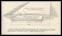 |
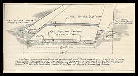 |
Diagrams from
California Highway Commission's 1920 Biennial Report demonstrating
two methods for adding "Second Story" concrete. Click on either
image for larger version.
Courtesy of Caltrans |
The
"second story" refers to a new layer of concrete poured over an older one. This
practice was especially prevalent in the 1920s when many 15 foot wide concrete highways were
widened to a more modern 20 foot standard. This combined the best of both worlds by creating a
new highway, but being able to use the old highway as a base. Examples of the second story
concrete exist on the old Ridge Route north of Los Angeles and on many sections of US 101.
"Suicide" Lane
In the 1920s and 1930s, many roads were
built with three lanes. There was one lane for each direction of traffic and a
shared middle lane that was
used for passing by vehicles going in both directions. This presented the very real
possibility for head-on collisions as passing vehicles from both directions often shared
this lane at the same time. The concept behind this lane is similar to the dashed yellow
line found on two lane highways, which permits passing. Suicide lanes were finally phased
out by the 1960s, with the roadways either being widened to a full four lanes (or more),
or simply having them removed. Today a "suicide" lane refers to the middle lane
of a road that can be used to turn left from both directions, which is similar to the
suicide lanes of yore.
Super elevation or Banking
This is where turns are raised on the outside to facilitate cornering. The best example of
what it is like is on racetracks where the road can be at a greater than 45 degree angle.
It is commonly used on freeway on ramps and has been in use since the very early days of
20th Century road building.
US Highway System
This refers to the system of
highways that preceded the Interstate Highway system and that is marked by black and white
shields. It was established in 1925 and was the world's first country-wide system of
uniformly numbered highways. It has played a major role in the development of the United States
in the 20th Century by making it possible to travel and transport goods over
long distances. While railroads also did this, the difference is that the
highways connected to many more places and had more flexibility of
transportation.
Return to the Historical US
Highways Page.