Historic US 99 Guide
Grapevine
Photograph courtesy of Caltrans. |
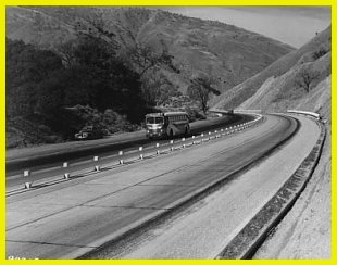
Lebec (1943)
This picture, looking north, was taken soon after US 99 was widened in 1943
going down the Grapevine Grade. The widening project was relatively simple: two additional
asphalt lanes were added and the former northbound (outside) lane lane was converted into
a center divider. Trucks used to use the white barrier fence in the middle as a brake by
rubbing against it. |
Tejon Pass and Grapevine Grade
The passage between Los Angeles and points north is possible because of the Tejon Pass.
However, many travelers are unaware that this passage was created by the San Andreas Fault
(as are the Cajon Pass and San Gorgonio Pass). Any amount of slippage on this fault could
create immense havoc with the freeway currently going through it; in many ways the highway
is hanging on a thread. This has been a factor in all highways constructed through here
since the original Ridge Route highway in 1915. Tejon Summit has always been a welcome
sight for drivers as it marked the end of the long climb going either way.
The Grapevine Grade has always been a daunting challenge for highway engineers from the
construction of the first modern highway in 1915 to the ones who worked on I-5 in 1960.
The first road was incredibly winding and closely followed the contours of the mountains.
A mere twenty years later, engineers were able to create a road with sustainable speeds
that could exceed 45 MPH, followed by the first four lane section of US 99 through the
mountains in 1943. The pinnacle of achievement, to date, is the eight lane I-5 which
follows both sides of the canyon and has been responsible for the complete transformation
of the canyon.
Top of Page

Gorman to Fort Tejon via Tejon Summit
US 99 north of Gorman may be accessed by taking the Gorman exit road away from the town
and to Peace Valley Rd, then making a right turn. Peace Valley Rd is a somewhat
interesting anomaly. For a brief time during 1965-66 it once constituted a portion of I-5
as a detour road for the massive freeway construction from Gorman north over Tejon Pass
to just beyond Frazier Park Rd. It was even mile posted as I-5, but it was never a
part of US 99. It is interesting since although it is now little more than a frontage
road, it is one built up to four lane mountain Interstate highway standards, having 12'
lanes and gentle curves. As such, the road looks it looks exactly like the sections of US
99 over Three Mile and Five Mile grades, though the scenery is far different. After some
distance going uphill, it reaches Tejon Summit, the highest point along the route of the
Liebre Mountains
Tejon Summit has changed changed in elevation no less than three times. The original
1915 Ridge Route crossed it near the summit of Peace Valley Rd and represented the
pinnacle of engineering on that incarnation of the highway. Like the rest of it, though,
the narrow road over the summit soon became obsolete and in 1923 "second story
concrete" was added to widen it. In 1933, the summit was changed as part of the major
realignment of US 99 and a more modern three lane road went over it. The summit was
again modified by the construction of the 1951 divided expressway which was a huge
improvement over its predecessors. However, the newer crossing over the summit lasted only
15 years before it was replaced by the eight lane I-5 freeway in 1966. In order to allow
I-5 to have a more gradual slope, a huge amount of the mountain was removed, altering the
landscape considerably and erasing the former summits. It was for this reason that the
Peace Valley detour was created.
The road in this area also has a lot of history behind it. Beyond the summit, Peace
Valley Rd continues downhill and is soon joined by the 1951 expressway. It merges in
slowly from the right and melds into the road. This is the best preserved section of the
US 99 expressway, with the original concrete continuing for almost one mile. What is of
even more interest is the remaining sections of the Ridge Route on the hill above. From
the road level they look like nothing more than a drainage ditch, but continuing along
Peace Valley Rd. reveals they are far more, as will be pointed out in the side trip.
The valley into which I-5 enters is an area of historic note. For one thing, it marks
the northern end of the Ridge Route and the start of the Grapevine Grade. It was the site
of Fort Tejon, now a state historic monument. Fort Tejon was established in 1854 to
suppress stock rustling, which was rampant, and to protect (and control) the Native
Americans in the San Joaquin Valley. While there were no Civil War battles in
the area, Civil War enthusiasts reenact battles scenes every year. During its time, it also became
the social center of the area, which is understandable since there was not much else
around - Los
Angeles was almost a two days' ride away. It was closed in 1863 after only nine years
of service.
While Fort Tejon lasted only nine years as an operational military installation, it
hosted its fair share of events. In 1857 it was near epicenter of the Fort Tejon
earthquakes, a series of tremblers that lasted three days. One of them, an 8+ trembler on
the Richter Scale had the same intensity as the one that destroyed San Francisco in 1906.
Despite the continuous trembling, there was not much damage to the fort and operations
were able to continue without interruption. This earthquake was the last major earthquake
on the San Andreas Fault. Geological evidence shows that a major earthquake has occurred
in the area every 150 years. 2007 will mark the 150th anniversary of the Fort Tejon
earthquake.
Fort Tejon was the location of one of the more novel experiments in American military
history: the camel brigade. This was the only attempt in American history to use camels
for military purposes - and with good reason. While camels are extremely hardy animals,
putting mules and oxen to shame as far as endurance and strength are concerned, they are
also very foul tempered. They also proved to be hard to ride and their bouncing gait gave
some of the men motion sickness. Interestingly, the project was the brainchild of then
Secretary of War, Jefferson Davis. He proposed that they could be used for hauling
supplies to California across the grueling Mojave Desert from Yuma in the Arizona
Territory. So, in 1861, under the guidance of Edward Beale, the same man who was
responsible for the construction of Beale's Cut to the south, the camels arrived at Fort
Tejon. After three years, the experiment was deemed a failure, due to the problems with
the camels. After that they were auctioned off, seeing service briefly hauling mail and
other items from San Pedro to Los Angeles. General Beale bought a couple which he used to
pull a sulky he used to ride down to Los Angeles.
|
The first road over the Tejon Summit was completed in 1915. However, as part of the
improvements to the Ridge Route in the 1920s, the road on the summit had second story
concrete. A portion of this is still visible on the hill above the 1951 expressway and can
be reached by hiking. |
Top of Page
Grapevine Grade
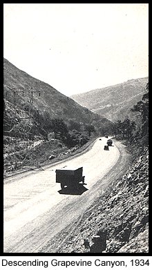 Perhaps the
most hazardous section for travelers going over the mountains was the Grapevine Grade
between Fort Tejon and the base of Grapevine Creek at the foot of the Central Valley, due
to the rugged terrain and dramatic changes in elevation. The original Ridge Route highway
built in 1915 was an absolute deathtrap. This section had 119 sharp turns, two with a
radius as small as 80' (a 10 MPH hairpin turn - the turning radius of an average car is
40') and when totaled caused the traveler to drive the equivalent of 12
full circles. As a testament to the hazards presented by this road, one turn was even
labeled "Deadman's Curve." By 1934 the extension of the US 99 Ridge Route
Alternate realignment and improvement was completed and offered a substantial improvement
in safety and ease of driving. For one, the number of turns was reduced to 23 and the
number of complete circles a driver would have to make was reduced to 1�. The length was
shortened by over a mile. Perhaps the biggest improvement was the widening of the road
from 20' to 30' with three 10' lanes. The addition of suicide lanes enabled motorists to
pass slow trucks and allow traffic to move more quickly as backups behind the slow
vehicles became minimized.
Perhaps the
most hazardous section for travelers going over the mountains was the Grapevine Grade
between Fort Tejon and the base of Grapevine Creek at the foot of the Central Valley, due
to the rugged terrain and dramatic changes in elevation. The original Ridge Route highway
built in 1915 was an absolute deathtrap. This section had 119 sharp turns, two with a
radius as small as 80' (a 10 MPH hairpin turn - the turning radius of an average car is
40') and when totaled caused the traveler to drive the equivalent of 12
full circles. As a testament to the hazards presented by this road, one turn was even
labeled "Deadman's Curve." By 1934 the extension of the US 99 Ridge Route
Alternate realignment and improvement was completed and offered a substantial improvement
in safety and ease of driving. For one, the number of turns was reduced to 23 and the
number of complete circles a driver would have to make was reduced to 1�. The length was
shortened by over a mile. Perhaps the biggest improvement was the widening of the road
from 20' to 30' with three 10' lanes. The addition of suicide lanes enabled motorists to
pass slow trucks and allow traffic to move more quickly as backups behind the slow
vehicles became minimized.
All three highway incarnations with the US 99 shield crossed Tejon Summit, but
all three have been taken out by the deep cut through which I-5 passes over the
summit. Between the Ridge Route days and the time US 99 was widened to four lanes,
there was a hotel, restaurant and gas station located right at the summit. Continuing
down, the 1951 expressway and the 1933 alignment once again are covered by I-5. This is
actually the last visible section of the original four lane US 99 until the Union Ave.
exit 27 miles to the north of of SR-99. Almost all of it was covered by I-5, which shows
that it was engineered well enough to be used as a part of an Interstate highway. Several
bridges from 1936 and the later widening are still in use as part of I-5, although they
appear no different from the road than more recent ones - however a lance toward the
median will show the date stamps on some of them.
The highlight here is that there are several well preserved sections of the Ridge Route
that remain in the area. The first is visible on Peace Valley Road, just beyond where it
departs from the newer alignment of US 99; it is a section of single slab concrete that
appears in the middle lanes right before the intersection with Frazier Park Rd. Peace
Valley road turns into Fort Tejon Rd. south of the intersection and roughly follows the
old Ridge Route. In some areas there are fence posts and other roadside markers that date
back from the Ridge Route. The road crosses I-5 over a bridge designated as the "Most
Beautiful Steel Bridge of 1963," or something to that effect. I still do not see its
scenic value. However, what is more scenic, and definitely more interesting is the
perfectly preserved stretch of Ridge Route immediately to the left of and parallel to the
road. This section has literally "gone out to pasture," as it is now on a horse
ranch. Once again, Fort Tejon Rd. covers the old alignment, but only to Lebec School,
where the old alignment is now used for school bus parking. Soon after, the canyon narrows
and it is necessary to enter I-5.
The section of I-5 from the Frazier Park Rd. to Fort Tejon Rd. was completed in 1966,
completely covering the 1949-51 alignment. As mentioned before, a few of the bridges from
the old alignment are still in use, but are now unrecognizable as they were widened with
the construction of the freeway. The section of freeway from the Fort Tejon Rd.
overcrossing to the San Joaquin Valley was the first segment built as I-5, being completed
in 1960 with the current eight lanes.
The freeway at this point continues to cover the old alignment of US 99. Like the rest
of the road through the mountains, this portion was completed at the end of 1934,
replacing the Ridge Route. However, this was the first segment to be widened to four
lanes, a project which was completed in 1943, during America's involvement in World War
II, a fact that shows how important widening that section of highway was. Originally it
was three lanes, but the widening converted it into a four lane divided highway by adding
asphalt on the outside of the lanes. Before the modern freeway replaced it, it was
possible to see the concrete lanes drift from one side to the other. The section between
the Fort Tejon overcrossing and Grapevine was also the site of an experiment which was to
have a great effect on California's freeways in later years, as it was one of the first
applications of a concrete barrier.
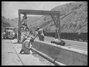 |
|
"Parabolic concrete deflectors being
placed
on the median strip on the Ridge Route,
U.S. 99." (1948) |
US 99 heading down toward the Central Valley was extremely steep, even after the 1943
realignment, which was a major problem for truckers. A wood and metal barrier was erected,
but it was damaged fairly quickly by trucks who would actually brush up against it to
provide more braking. To counter this, the Division of Highways conducted an experiment in
1946 in which a two foot tall parabolic concrete barrier would be used in place of the
metal barrier on wooden posts. The new barrier was made up of 10 foot sections each
weighing 3000 lbs. This barrier, which has an uncanny resemblance to today's concrete "Jersey Curbs", was wide on the bottom, then tapered
off toward the top. This proved to be very effective in deterring trucks from further
abusing the median barrier. It also proved very effective in preventing head-on collisions
as wandering and out of control cars were usually deflected from the barrier.
About one mile beyond the Fort Tejon overcrossing, I-5 splits and goes down both sides
of Grapevine Canyon. It is separated so that the more modern northbound side can make a
more gradual descent into the San Joaquin Valley, similar in concept to what is employed
at Five Mile Grade where the gentler descent adds safety by not allowing trucks to build
up as much momentum. Despite this, the stench of burning brake permeates the air at the
base on an almost ongoing basis. The original routing of US 99 is now under the southbound
lanes, but it remains otherwise unchanged. As mentioned before, this section was built in
1936 and offered a considerable improvement over the neighboring Ridge Route. Originally
it was three lanes of concrete, but this proved too dangerous and in 1943 it was widened
to four lanes. Due to the shortage of supplies during World War II, the widening simply
consisted of adding asphalt and using it to straighten out the road. Before the modern
freeway replaced it, it was possible to see the concrete lanes drift from one side to the
other.
Top of Page
Grapevine
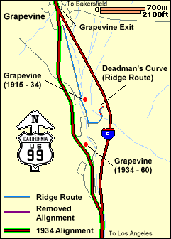 Grapevine has long been a
fixture of traffic along US 99 and later I-5. It predates US 99 having catered to
travelers on the Ridge Route from 1915. It served as a rest area for both travelers
exhausted from the journey over the mountains and for those about to conquer them. The map
at right shows how it has moved over the years. Today it lies at the bottom of the grade
at the point where both sides of I-5 reunite. Before 1960 it was located further up the
hill along the southbound lanes of I-5, which are paved over US 99, and before 1934 it was
located nearer its present location, right at the point where the Ridge Route started its
tortuous ascent. During its heyday it was a bustling place with an array of gas stations,
restaurants, and motels. Today all that is left is the skeleton of a large wooden sign
that once proudly displayed the Union 76 logo and the fading outlines of buildings on the
ground.
Grapevine has long been a
fixture of traffic along US 99 and later I-5. It predates US 99 having catered to
travelers on the Ridge Route from 1915. It served as a rest area for both travelers
exhausted from the journey over the mountains and for those about to conquer them. The map
at right shows how it has moved over the years. Today it lies at the bottom of the grade
at the point where both sides of I-5 reunite. Before 1960 it was located further up the
hill along the southbound lanes of I-5, which are paved over US 99, and before 1934 it was
located nearer its present location, right at the point where the Ridge Route started its
tortuous ascent. During its heyday it was a bustling place with an array of gas stations,
restaurants, and motels. Today all that is left is the skeleton of a large wooden sign
that once proudly displayed the Union 76 logo and the fading outlines of buildings on the
ground.
Top of Page
![[Historic Highways Logo]](../logos/small_hcuh_banner.gif)
Go to the Historic California US Highways Main Page
Top of Page
If you have any questions, comments, or if you would like to send me any
updates or pictures, please contact me at: casey@gbcnet.com.
Frame URL: http://www.gbcnet.com/US99/US99g.html
